U.S. ROUTE 82
RED RIVER-BOWIE COUNTY LINE TO FM 259
Aerial Data Service, Inc. (ADS) obtained 4-band digital imagery at an altitude of 2,278’ Above Mean Terrain (AMT) providing for digital imagery with a Ground Sample Distance (GSD) of 5cm along US 82 in Bowie County, Texas. The multispectral imagery was obtained with ADS’s calibrated precision UltraCam Falcon digital aerial mapping camera equipped with Forward Motion Compensation (FMC). Airborne GPS (ABGPS) and Inertial Measuring Unit (IMU) data was logged simultaneously with the acquisition of the imagery and refined in the analytical aerotriangulation process.
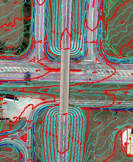
Aerial Data Service (ADS) processed airborne LiDAR data obtained with a helicopter for the approximately 7.5 mile long, 300’ wide corridor for incorporation into a photogrammetric data set. Our technicians collected digital data at 1" = 40' scale for planimetric features that were identifiable on, or interpretable from, the digital imagery. Planimetric features collected included; buildings, roads, railroads, drainage features, bridges, culverts, fences, driveways, poles, sidewalks, individual trees, fire hydrants, manholes, catch basins, etc. ADS developed a Digital Terrain Model (DTM) from the aerial photography by supplementing the processed airborne LiDAR data (bare-earth) with breaklines depicting rivers, streams, lakes, ridge lines, slope breaks and other significant features as required to properly depict the ground surface. Digital mapping was prepared to meet American Society for Photogrammetry and Remote Sensing (ASPRS) Class I standards for 1” = 40’ scale map accuracy with a one foot contour interval. Orthophotos were developed from the DTM and imagery data with 3-inch pixel resolution. All work was tied to control information provided by the client.
Computer-Aided Design and Drafting (CADD) software was utilized in preparation of the deliverables which included; topographical and planimetric data in MicroStation V8/GeoPak formats and digital orthophotography image files in TIF/TFW format.