Digital Mapping

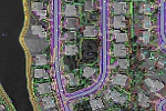
Aerial Data Service, Inc. (ADS) uses softcopy workstations with Cardinal System’s VR software for planimetric and DEM data collection. This technology allows aerial photographic raster images and map data to be viewed three-dimensionally. After map compilation, cartographic editing is performed. Contours are determined from DTM data, labels are added and final tiles are extracted and plotted. For Geographical Information System (GIS) and engineering design, our cartographic editors review the data to ensure that it is ready for system implementation. Maps and DTM data are delivered in all popular software formats, including AutoCAD®, MicroStation® and ESRI.
The Federal Services Department has provided timely, accurate, mission critical and feature rich datasets for our customers for over a decade. With over 60 years of mapping experience, the staff at ADS has provided support for DNC, FFD, LOC, UFD and various crisis support projects.
 Back to Services

