VANCE AIR FORCE BASE RUNWAY REHAB
ENID, OKLAHOMA

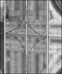
Aerial Data Service, Inc. (ADS) collected extensive mobile LiDAR data along the 9200’ main center runway and associated taxiways of Vance Air Force Base in Enid, OK using our Optech LYNX Mobile LiDAR system. The LYNX is a Dual 360-degree laser system equipped with on-board Global Navigation Satellite System (GNSS), Inertial Measurement Unit (IMU) and Distance Measurement Instrument (DMI) capable of collecting 400,000 points per second with a range of 200 meters. The system is vehicle mounted to collect data in a crossing pattern, greatly minimizing shadowing from obstacles such as buildings, trees, poles and like features.
The project area was collected at a speed of approximately 20 miles per hour with multiple overlapping passes and angles to ensure adequate LiDAR coverage and full data set over the entire project area.
Data collection was monitored in real-time by the system operator, ensuring that there were no anomalies or adverse circumstances including loss of GPS reception, improper function of the laser scanner, proper area coverage and assuring that optimal vehicle speed was maintained to meet project requirements. Simultaneous base station data was collected before, during, and after LiDAR acquisition using survey-grade GPS units to tie the LiDAR data to the horizontal and vertical geodetic control network for complementary post-processing of the on board GNSS/IMU system information.
Seaside Engineering and Surveying, LLC (SEAS) calibrated the LiDAR data, developed automatic routines to classify the LiDAR data, and then manually edited the classified data to provide a final bare earth LiDAR data set. LiDAR data was determined to have a Root Mean Square Error (RMSE) of 0.011 feet by comparing the LiDAR data to 58 control points established by the client.
Aerial Data Service (ADS) extracted breaklines and interpolated a mass point grid from the final bare earth LiDAR data set to create a surface model. The surface model was provided in AutoCAD/XYZ format. Planimetric features which were identifiable in the LiDAR data were extracted and delivered at 1” = 20’ scale in AutoCAD format. The planimetric features included edge of pavement, change of pavement, joint lines, and all runway/taxiway striping.
Digital terrain model (DTM) data and 3D surface line work were delivered in AutoCAD/XYZ format. Edge of pavement, change of pavement, joint lines and striping were delivered in AutoCAD format.
 Back to Projects

