Digital Orthophotography
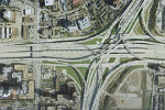
Aerial Data Service, Inc. (ADS) uses digital orthophoto technology to create images that are a scale representation of the terrain surface. Digital orthophotos combine recent technological advances in the fields of photogrammetry and graphic arts production. Specialized software enables the user to place the ortho-corrected imagery into the most recent CADD and Geographical Information System (GIS) environments.
To create orthophotos, ADS acquires the digital aerial photos, establishes a coordinate system for the photograph, performs aerotriangulation to transform the photo coordinates to ground coordinates, and then creates a digital elevation model (DEM) from the resulting stereo-photography. With this data, a pixel-by-pixel orthophoto rectification is performed to develop the orthophoto – a geo-referenced, scale-correct representation of the terrain surface.
Digital orthophotos are commonly used as a layer in a GIS. They can also be used for planning purposes, drainage studies, plan and profile sheets, and corridor alignment studies. Ink-jet, electrostatic, and thermal plotters can be used to plot digital orthophoto images. If desired, vector data (line work) can be superimposed over the image.